The NH Stone Wall Mapper project uses Lidar data to display small variations in ground elevation. A UNH project built this map to identify stone walls in the state.
This site can be “misused” (in a good way) to show lots of other topographic features. Here’s a “Lidar view” of the grounds of Loch Lyme Lodge, near Post Pond. The features are shaded as if the sun were shining from the northeast. (Update: 31 Dec: Thanks to the good folks at the NH Geological Survey, the link now goes directly to the desired view!)
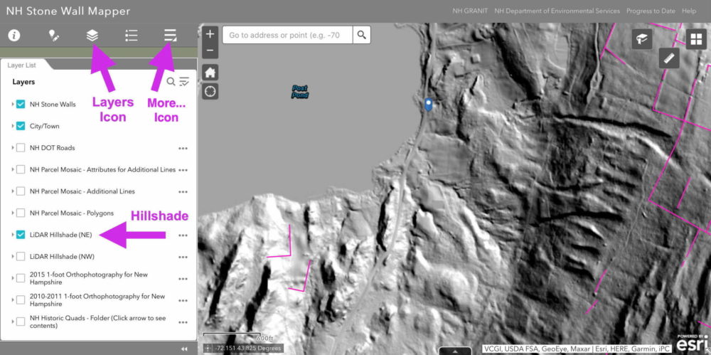
But wait… there’s more! You can turn on and off various “layers” to see other kinds of information. To do this:
- At the top-left, click the Layers Icon to display various layers
- Check on or off the Hillshade box to “show or hide the trees”…
- Click the More… icon to enable other features, such as the “Swipe Layers” that lets you compare two layers…
So much fun – play around!. Turn on/off layers, scroll to other parts of NH. If you find something interesting, send me a note and I’ll post it. Enjoy!
Hi Rich,
I’ve been working with Rick Chormann on the development of the mapper and using it for all sorts of interesting projects as well. Today the mapper is officially 2 years old and both Rick and I are looking for ideas on where it might go in the future. Let’s talk.
Hi Steve, Thanks for this note. I really liked your site. And now I know why “Lime Kiln” roads are so prevalent in other areas – they were a big deal. I have been corresponding with Rick myself: he tweaked up the Stone Mapper site so that people could save a full link to a particular location and set of layers. That’s how you can look at the Lodge property – with Lidar view and property bounds – in one click.